Rooftop Modeling Flight
Rooftop Modeling requires two flights: a mapping flight and an orbital flight.
MAPPING FLIGHT
Image captured during a mapping flight.
Resolution & altitude:
2 cm/pixel (.8 in/px) at rooftop level
Approximate altitude: 91.4 m (300 feet) above ground level (AGL)
Example: For a building 45 ft tall (13.7 m), approximate AGL of 300ft (91.4 meters)
Gimbal pitch:
Nadir (straight down)
-90 degrees from horizon
Overlap:
75% front overlap, 75% side overlap
Flight area:
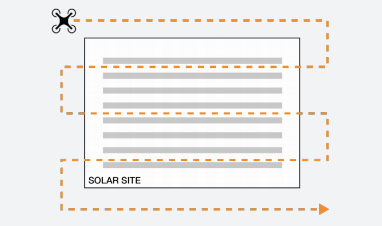
The flight path should cover the entire site with a grid flight pattern

Flight path
ORBITAL FLIGHT
Sample image from an orbital flight
Altitude:
- One set of orbital images at ~100 ft above the rooftop
Gimbal pitch:
Approx. 30 degrees facing toward the center of the site
Do not include any sky in the view or image
Flight area:
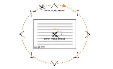
Flight should be flown in a circle around entire perimeter of site; fly elliptically for longer rectangular buildings
OBLIQUE FLIGHT
Altitude:
76.2 to 91.4 (250 to 300 feet) above ground level (AGL)
Gimbal pitch:
Oblique, -15.0 to -45.0 from horizon
Flight area:
6.1 hectares (15 acres) per mission
Approximately 3 megawatts or less
Inner Facing Images:
Typically 8 image captured at 130 m (600 ft) radius from the center in 8 principal compass directions.
Outer Facing Images:
Typically 8 image captured from the center of the site in 8 principal compass directions.

Updated 5 months ago
