Drones: Topography & Contours
Compatible Hardware
Images must be JPEG and contain metadata (GPS, relative altitude, gimbal altitude, and timestamp)
Make | Model | Camera | Flight Mission | 1 GCP | 6-10 GCPs |
|---|---|---|---|---|---|
DJI | Phantom 4 | Built-In | Ortho, Orbital | No | Yes |
DJI | Phantom 4 Pro | Built-In | Ortho, Orbital | No | Yes |
DJI | Phantom 4 Pro V2 | Built-In | Ortho, Orbital | No | Yes |
DJI | Phantom 4 RTK | Built-In | Ortho, Orbital | Yes with D-RTK 2 Base Station | Yes |
DJI | Inspire 1 | Zenmuse X3, Zenmuse X5 | Ortho, Orbital | No | Yes |
DJI | Inspire 2 | Zenmuse X4S, Zenmuse X5S with 15mm DJI lens. | Ortho, Orbital | No | Yes |
DJI | M200 | Zenmuse X4S, Zenmuse X5S with 15mm DJI lens. | Ortho, Orbital | No | Yes |
DJI | M210 RTK | Zenmuse X4S, Zenmuse X5S with 15mm DJI lens. | Ortho, Orbital | No | Yes |
DJI | M200 V2 | Zenmuse X4S, Zenmuse X5S with 15mm DJI lens. | Ortho, Orbital | No | Yes |
DJI | M210 RTK V2 | Zenmuse X4S, Zenmuse X5S with 15mm DJI lens. | Ortho, Orbital | Yes with D-RTK 2 Base Station | Yes |
DJI | M300 | P1 (coming soon) | |||
DJI | M600 | Please ask for more information | |||
DJI | Mavic | Built-In | Ortho, Orbital | No | Yes |
DJI | Mavic 2 Pro | Built-In | Ortho, Orbital | No | Yes |
DJI | Mavic 2 Enterprise | Built-In | Ortho, Orbital | No | Yes |
Sensefly | Ebee Classic | S.O.D.A | Ortho | No | Yes |
Sensefly | Ebee Plus | S.O.D.A | Ortho | Yes with Base Station | Yes |
Sensefly | Ebee X | S.O.D.A 3D, Aeria X, S.O.D.A | Ortho | Yes with Base Station | Yes |
Parrot | ANAFI | Built-In | Ortho, Orbital | No | Yes |
Parrot | ANAFI USA | Built-In | Ortho, Orbital | No | Yes |
Autel | Evo II | Built-In | Ortho, Orbital | No | Yes |
Skydio | X2 | Built-In | Ortho, Orbital | No | Yes |
BE SURE TO ALWAYS USE GROUND CONTROL POINTS.
See table if a single GCP can be used, otherwise you will need 6-10 GCPs.
Special considerations:

GCPs
Propellor Aeropoints is the easiest way to collect GCPs.
Make sure site is in the Propellor Corrections Network
Follow these instructions to download a copy of the user manual

From propelleraero.com Aeropoint Manual
Manual GCPs:
These need to be identifiable and surveyed GCPs meaning that the position and elevation are known precisely typically using a correction network and the GCP can be easily identified from nadir drone imagery.
GCPs may exist on the site already from construction or other surveys, which can be used if they can be easily identified from nadir drone imagery. If using pre-existing GCPs we need to know the coordinate reference system (aka datum) used.
Preferred Datum:
We like to use the customer’s preferred coordinate reference system if they have one they are using for the site.
If they do not have one we prefer the following:
Horizontal datum: WGS 84 latitude/longitude.
Vertical datum (USA): NAVD 88 elevation
Vertical datum (non-USA): EGM84, EGM96, or EGM2008
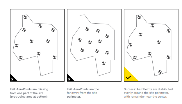
GCPs should be on the ground and distributed evenly around the perimeter with remaining GCPs distributed evenly in the center.
Do not make GCPs on top of an inverter or other onsite equipment.
Updated 4 months ago
